Most Models for Hurricane Ian Switched Projected Landfall Locations from Southern Tampa Bay Region to south to Charlotte Harbor (Lee County, FL.) in less than 24 Hours of Actual Landfall (50 miles+)
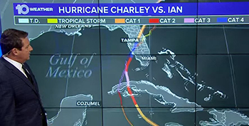 October 11, 2022 – Although most of the models and weather channels finally targeted the Cayo Costa, FL. landfall location in less than 24 hours, it was too late for a complete evacuation to escape the catastrophic storm surge of up to 18 feet above ground for those living on the barrier islands (Sanibel and Captiva) and beach communities of Ft. Myers Beach and the coastal Naples area. All week, the projected landfall was Tampa Bay and north. When Hurricane Ian was projected to cross the western tip of Cuba (about 3 days before Florida landfall), it was eerily familiar to me when I recalled Hurricane Charley back in 2004. Sure enough Big Brother Ian followed closely the same track but with a larger eye and slower movement into the warm waters of Charlotte Harbor to build a record-breaking storm surge and inland flooding. The 24-hour differences in the modeling tracks are shown below.
We have heard from our Southern Run customers who suffered damage including flooded cars but they are recovering during the aftermath of the storm (which can be even more mentally and physically challenging than the storm itself). I have to ask why didn’t more models show this possibility of a direct hit south of the Tampa Bay region? and will the programming be updated to safeguard against a repeat in short-time warnings?
Charlotte Harbor seems to have an electronic pull for hurricanes in the Gulf of Mexico that seek warmer bay waters to sustain energy. Hurricane Charley devastated the Town of Punta Gorda and the modest homes along Route 17, many of the residents are agricultural workers. It was heartbreaking when I traveled there for planning projects in the two or more years after Hurricane Charley’s path. The only silver lining is that Punta Gorda built back stronger in compliance with the current Florida Building Code.
Here are some of the stats for Hurricane Ian:
First Landfall as a Category 4: Wednesday, September 28, 2022, Cayo Costa, Florida, at 3:05 p.m. EDT
Maximum Sustained Winds: 155 mph, just shy of a Category 5 storm (our neighbor measured a maximum wind gust of 150 mph in eastern Sarasota County when we lost major trees the night of September 28, 2022 from the collision of powerful northeast bands from Hurricane Ian and a high front to the north).
Strength: Rated by NOAA as the fifth-strongest hurricane on record to strike the United States.
Torrential Rainfall in Eastern Sarasota County: It was a 1-in-1,000-year flood event including the Myakka River that flows into the Charlotte Harbor. Our neighbors to the north of the Myakka River were flooded when an earthen dike breached early morning of September 30, 2022 … losing houses, barns and their cows and horses. Gratefully, the AquaNew office building did not flood but the flood waters of the Myakka River were within 6 paces of the eastern side of the building.
Supposedly, adversity makes us stronger but we think Floridians are strong enough and we hope our strength is not tested for a long time to come. We want to extend our appreciation to the Texas power crew who cut large trees to reinstall our power line and also all of those who check-in with us. Rob, Dewey (our cat) and I are fine and very grateful.
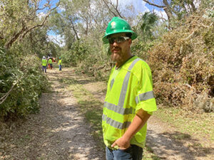
Texas power guys cutting trees to restore the power line to the AquaNew building, Wednesday, October 5, 2022.
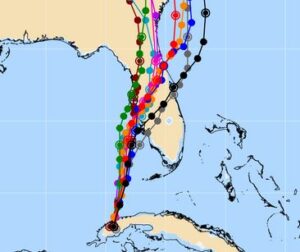
Hurricane Ian Models, Day Before Landfall, Tuesday, September 27, 2022, noon. U.S. Navy Source
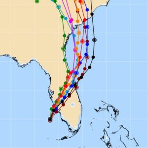
Hurricane Ian Models, Day of Landfall, Wednesday, September 28, 2022, noon. U.S. Navy Source